 June 20. The drive from Whitehorse to Dawson City was uneventful. The
highlight of the 300+ mile drive was stopping for a GIANT cinnamon roll we
missed in 2010. You’ve heard of all day suckers? Well, this cinnamon roll was a
breakfast for a week roll. I put my hand up against the gigantic thing so you would
have some perspective. I was amazed that the entire roll was cooked through. So
often the center is doughy and nasty. It was delicious. Jim has one more
breakfast left and it will be gone.
June 20. The drive from Whitehorse to Dawson City was uneventful. The
highlight of the 300+ mile drive was stopping for a GIANT cinnamon roll we
missed in 2010. You’ve heard of all day suckers? Well, this cinnamon roll was a
breakfast for a week roll. I put my hand up against the gigantic thing so you would
have some perspective. I was amazed that the entire roll was cooked through. So
often the center is doughy and nasty. It was delicious. Jim has one more
breakfast left and it will be gone.
 Here is Maggie on point. She is willing the “magic glove box
that holds the special treats” to open.
Sort of like the old Mervin’s commercials…….open, open, open. She can only do this trick when the truck is stopped;
otherwise she runs the risk of kissing the floorboard when we hit a frost heave
in the road!
Here is Maggie on point. She is willing the “magic glove box
that holds the special treats” to open.
Sort of like the old Mervin’s commercials…….open, open, open. She can only do this trick when the truck is stopped;
otherwise she runs the risk of kissing the floorboard when we hit a frost heave
in the road!
Dawson City is pretty cool this time. There are a zillion
dual sport bikers (dualies) here for a rally. These are not your Hell’s Angels
bikers. These are “normal” friendly people with very expensive bikes.
Their bikes are at home on dirt roads and highway. And they’re all
geared up with protective clothing, fancy helmets, heavy boots, etc. You should see the saddle bags, side cars, and
other means of storing stuff on a long ride. Nice bunch of people.
 Dawson City has made some improvements since we were here in
2010. Main Street is now paved, but it still looks like a dirt road. However, the rest of the town is still dirt
roads. The town was home to Jack London (who wrote the books “Call of the Wild”
and “White Fang”) and Robert Service (who wrote the poems “The Shooting of Dan
McGrew” and “The Cremation of Sam McGee.”) There are a lot of references to the two men
in paintings, murals and wall decor.
Dawson City has made some improvements since we were here in
2010. Main Street is now paved, but it still looks like a dirt road. However, the rest of the town is still dirt
roads. The town was home to Jack London (who wrote the books “Call of the Wild”
and “White Fang”) and Robert Service (who wrote the poems “The Shooting of Dan
McGrew” and “The Cremation of Sam McGee.”) There are a lot of references to the two men
in paintings, murals and wall decor.
There are a number of brand spanking new
buildings, mostly tourist housing for the ship lines. Much of the town is still
dilapidated homes from the 1800’s. Some
have been red tagged as unsafe to enter. The problem for these buildings is not
age so much as it is melting permafrost causing the foundations to fail. These
two buildings were in bad shape when we were here before; I am amazed they’re
still standing given how much they’re leaning! Then there is this house with a
bunch of old electrical boxes on it.
We drove out to see Dredge Number 4 today. Glad to see that it
has been placed on the National Historic Register. New paint, lots of repairs
and new interpretive signs.
Afterwards
we stopped at Claim #6 to do a little free gold panning. Alas, Jim found only one itty bitty, teeny weenie
flake of gold. We checked out the surrounding area and found a lot of abandoned
gold dredging equipment. Also saw several active mines. It’s pretty cool just poking around the back
roads. Somewhere up here is Todd Hoffman’s mine from “Gold Rush.”
Tonight we went to the Diamond Tooth Gertie’s to see a show.
LOVED this show, Gertie is an awesome entertainer and “her girls” are great
fun. As so often happens with these
shows a man was pulled out of the audience to assist the dancers. They dressed
him in a can can skirt and feathered headband and had him doing kicks, twirls
and flipping up his skirt to “show the audience what his Momma gave him.”
Gertie’s is also has a gambling casino. Needless to say, this is a very popular
place.
June 23. We are off to drive the Dempster Highway. It’s about a thousand miles round trip.
The Dempster was much different than our drive on the Dalton
in Alaska in 2010. The Dempster runs through Boreal and Taiga Forest almost the
entire way. The scenery is just beautiful. The Richardson Mountains are a spectacular backdrop for the Dempster Highway. The Dalton had almost 250
miles of Taiga Plains where herds of Caribou and Musk Ox roamed. The Dempster
is dirt road for 457 miles. During the drive we came across several road crews watering,
grading and spreading calcium on the road. I think this road must be like the
Golden Gate Bridge, where painters spend their entire career painting the
bridge, again and again and again. In
summer they work on the dirt road, in winter the frozen road is transformed
into the ice road.
Besides the dirt road there are two ferries you have you to
take. So when road workers get up in age they transfer to the ferry service
which is considered easier work.
Thanks
to all the road crews the road was in excellent condition and we were able to
drive 50 - 60 miles an hour. Of course
when we came across other vehicles we had to slow to 20 because of all the dust.
The dust obliterates your view of the road for several seconds.
At the half way point
(mile 229) we stopped for the night at Eagle Plains Hotel and Campground. This place
is literally in the middle of nowhere. The hotel manager told us that when they
hire summer help they try to be VERY HONEST about the location and conditions
so new employees will not be surprised when they arrive. She said last year
they had a young woman arrive for work; she took one look around and started
crying. She promptly hitched a ride with a trucker back to Dawson City! The
manager said people either love it or hate it here. The food is very good here. I guess with this
being the only stop for truckers on the year round haul road a good hearty food
is a requirement. We found the same to
be true of the restaurant at Coldfoot, half way point on the Dalton. Eagle
Plains was built by the Canadian government in the late 70’s for 3.5 million.
It includes a full service gas station, road maintenance facilities, laundromat,
tow truck and air radio facilities.
 The Dempster also has two road/airstrips for emergency
landings. I guess I never thought about
where planes land in the Yukon when they are in trouble. From the looks of the road/airstrips they can accommodate
big planes. I am just glad nobody tried to land with us on the road!
The Dempster also has two road/airstrips for emergency
landings. I guess I never thought about
where planes land in the Yukon when they are in trouble. From the looks of the road/airstrips they can accommodate
big planes. I am just glad nobody tried to land with us on the road!
We did not see any large mammals, such as Moose, Bear or
Caribou on the drive to Inuvik. We did see Arctic Hares scampering across the
road. I was also surprised to see most
of the ponds were barren of ducks and there were very few song birds in the
trees and bushes. A stop at the
Interpretive Center at Tombstone confirmed my lack of bird’s observation. I was
told very few birds made it to the Yukon this year. The ones who did (mostly
song birds) died in a late spring blizzard. But not all was lost; the Foxes had
a feast on bird carcasses!
 35 kilometers north of Eagle Plains we crossed the Arctic
Circle. The sun will not set here for the next 50 days. Black out shades are a necessity up here if
you hope to get any sleep.
35 kilometers north of Eagle Plains we crossed the Arctic
Circle. The sun will not set here for the next 50 days. Black out shades are a necessity up here if
you hope to get any sleep.
The second half of the drive included the ferry crossings. One
crosses the Peel River and the other crosses the HUGE Mackenzie River and the
Arctic Red River. From November to late
April these rivers are frozen and you drive across them. The MacKenzie drains one fifth of Canada. This drainage is exceeded only by the
Mississippi and the Amazon.
At mile 342 we stopped in Fort McPherson for diesel and a
bite to eat. This is a tiny aboriginal town of about 900 Tetlit Gwich’in people. It also holds the grave of Sergeant J. Fitzgerald and the Lost Patrol. The story goes that John Dempster a North West Mounted Policeman was tasked with finding a patrol lost in the wilderness. The search by dog sled in 1911 for the Lost Patrol was
brutal. He stayed out in the wilderness for almost two months, crossing and
recrossing the route trying to find the men. He eventually found the patrol,
frozen to death, only 26 miles from home.
 Mile 457 and we are Inuvik! It was not what I expected. Inuvik
is a planned community with brightly painted houses on stilts that line the paved
roads. It’s a modern and well maintained town with a population of 3,504
people. The mean temperature here is 14.54 F. While we were here one day was
45F and the next was 90F! The entire town runs on six HUGE natural gas
generators. Because the entire town is
built on Permafrost all services to houses and commercial buildings are run
above ground in a “Utilidor” system. Water is pumped in and sewage is pumped
out using the Utilidor system. It takes
some getting used to seeing all the metal culverts snaking through town. Many of the residents here are aboriginal. The
town is the seat of the Gwich’in Tribal Council.
Mile 457 and we are Inuvik! It was not what I expected. Inuvik
is a planned community with brightly painted houses on stilts that line the paved
roads. It’s a modern and well maintained town with a population of 3,504
people. The mean temperature here is 14.54 F. While we were here one day was
45F and the next was 90F! The entire town runs on six HUGE natural gas
generators. Because the entire town is
built on Permafrost all services to houses and commercial buildings are run
above ground in a “Utilidor” system. Water is pumped in and sewage is pumped
out using the Utilidor system. It takes
some getting used to seeing all the metal culverts snaking through town. Many of the residents here are aboriginal. The
town is the seat of the Gwich’in Tribal Council.
We had planned to visit Pingo National Landmark but there
were no good solutions for us. For $550 each you could either boat the Mackenzie
to Tuktoyaktuk and then take a flight home which over fly’s the pingos. Or you
could fly 50 minutes to Tuktoyaktuk, take a two hour driving tour of the town
and then fly home (seeing the pingos as you go by.) What I wanted to see were
the Pingos up close. Which is like a $500 flight, plus you have to hire a boat
and guide to take you out to the Pingos. I didn’t even ask the cost because I knew it
would be a whopper.
While we were in Inuvik we were invited to a community feast
and Treaty signing between the Canadian Federal Government and the Tribal Council
transferring decision making for the Northwest Territory back to the people. While
it gave them back control of land, mineral, timber, water, etc., it omitted
title to offshore drilling. So once again I think the Indians got screwed by
the white man. The evening was amazing! Tons of food, hundreds of people,
speeches by the Canadian Government, the Gwich’in Chief, the Mayor, etc.
Afterwards there was dancing.
You will never believe the Aboriginal dancing. They call it a
“Traditional Old Time Dance” but it looks like square dancing to a fiddle. Most
of the young people were dressed in traditional clothes for the dance. Girls in
calico dresses, boys with beaded leather vests and everyone in beautifully
beaded Mukluk slippers. And each dance goes on and on, and on and on, and on
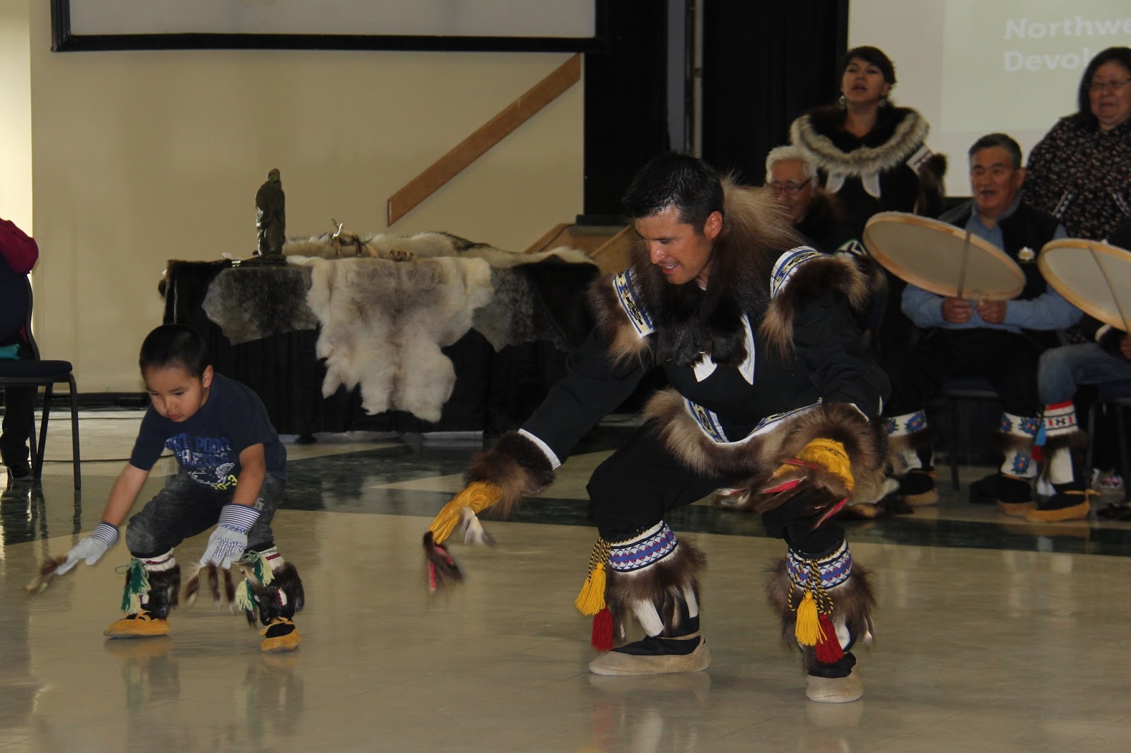
and on (you get the idea.) You would think they would drop from exhaustion! Next came the Inuvik Drummers and Dancers.
Their elaborate fur costumes are gorgeous (and hot.)
Each dance tells a story
of the Inuvialuktun way of life.
Children learn the complex dances by joining
in the dancing with their parents.
Even
tiny tots like these join in. We were so lucky to be in Inuvik at just the
right time! As we were leaving the feast I thanked several of the Drum Dancers
and they told me about next year’s festivities. Tribes from all over are coming
for a huge celebration and dancing. Wouldn’t that be cool?

Here’s a photo of me
with one of the Drum Dancer Elders and a young woman we met named Annemieke (I just
call her shorty.)
She is touring Canada and the
USA alone by motorcycle. Apparently, she
has the wanderlust like us. Annemieke is
from Delft, Holland. Be sure to check
out her blog – www.nenniearoundtheglobe.nl
 While we were in Inuvik Maggie PROVED she is a Basenji. We
were in a really nice hotel and Maggie discovered the Kleenex dispenser! I kept
hearing a sound I could not identify and so I went to check on Maggie. All I
could see was her tail at the bathroom door. She would step into the bathroom,
pull out a Kleenex, spit it out, step back, look at the dispenser, step back in
the bathroom, pull out another Kleenex, spit it out, step back, etc. etc. The bathroom floor was covered in Kleenex! No
idea what she was thinking? She repeated this trick when we went to dinner
later. Many Basenji’s love unrolling toilet paper, so maybe this was Maggie adaptation
of the Basenji toilet paper trick.
While we were in Inuvik Maggie PROVED she is a Basenji. We
were in a really nice hotel and Maggie discovered the Kleenex dispenser! I kept
hearing a sound I could not identify and so I went to check on Maggie. All I
could see was her tail at the bathroom door. She would step into the bathroom,
pull out a Kleenex, spit it out, step back, look at the dispenser, step back in
the bathroom, pull out another Kleenex, spit it out, step back, etc. etc. The bathroom floor was covered in Kleenex! No
idea what she was thinking? She repeated this trick when we went to dinner
later. Many Basenji’s love unrolling toilet paper, so maybe this was Maggie adaptation
of the Basenji toilet paper trick.
 I wanted to get a nice souvenir of Inuvik so we went to the Tribal
Council Offices which maintains a small shop of local handmade items. I have always loved what I call “Eskimo Dolls.”
Sure enough they had a nice selection of dolls. Unfortunately the one I fell in
love with was $250 Canadian! The doll has bloomers, a full calico slip, calico dress,
hand embroidered gloves and mukluks. Over all of that she has a beautiful fur
coat with hood. This is the softest thing I have ever felt. Rabbit, Beaver and
Muskrat pelts were used to make the coat. I have a guilty conscience for buying
the doll, but I just love it. I named her Rosie after Rosie Albert, the Gwich’in woman who made
her.
I wanted to get a nice souvenir of Inuvik so we went to the Tribal
Council Offices which maintains a small shop of local handmade items. I have always loved what I call “Eskimo Dolls.”
Sure enough they had a nice selection of dolls. Unfortunately the one I fell in
love with was $250 Canadian! The doll has bloomers, a full calico slip, calico dress,
hand embroidered gloves and mukluks. Over all of that she has a beautiful fur
coat with hood. This is the softest thing I have ever felt. Rabbit, Beaver and
Muskrat pelts were used to make the coat. I have a guilty conscience for buying
the doll, but I just love it. I named her Rosie after Rosie Albert, the Gwich’in woman who made
her.
On the long drive back to Dawson City we finally saw some
Moose. One cow and two bulls later we
have some great Moose pictures (hooray!)
Today is Jim’s Birthday, he is 69. For his birthday I let him
do the laundry and the dishes while I edited all our photos and blogged. For dinner we went to Klondike Kate’s. We split a 16 oz steak and half a pound of
crab legs. Jim had mud pie dessert. It was loaded with whip cream and chocolate
syrup. While we were there a band came in to play. They call themselves
Itinerant Musicians, roaming the Klondike playing where ever they’re welcome. It was a nice ending to a great meal.
 Last night at 12:30 I am Blogging away when a Cross Fox wanders through the campground. Several people came out to take pictures of him. I was sorry to see he was not afraid of people. He sure was cute!
Tomorrow we cross the Yukon River by ferry and drive The Top
of The World Road to Chicken, Alaska.


 Had a young
man stop to say goodbye to all the locals. He was off to college to learn
how to make wooden hull sailboats. He says he’s excited to learn how to steam bend
wood. Who knew there was a college degree in sailboats? As I said the town is prospering, they put in public toilets for all the tourists. It's called the Chicken Poop and it's a three holer. Pretty up town.
Had a young
man stop to say goodbye to all the locals. He was off to college to learn
how to make wooden hull sailboats. He says he’s excited to learn how to steam bend
wood. Who knew there was a college degree in sailboats? As I said the town is prospering, they put in public toilets for all the tourists. It's called the Chicken Poop and it's a three holer. Pretty up town. 


